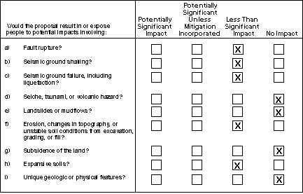
III. GEOLOGIC PROBLEMS
The project site is located on an
alluvial terrace along the west side of Los Gatos Creek at an
elevation range of 288 to 295 feet above sea level. The site has
been previously graded so that it is essentially flat, with a
gentle slope downward to a runoff catchment, about four to five
feet deep, on the east side.
- The main potential hazard to
structures and people on site would be from seismic
activity. Because the site would be fenced and locked,
direct public access would be prevented. No workers would
be present on the site, except during brief periods of
occasional maintenance and inspection activities.
Therefore, the potential for injuries to people on the
site during earthquakes would be only a remote
possibility. The earthquake hazards are potentially
significant only for the facilities themselves. To the
extent that these would be rendered inoperable by an
earthquake, resulting in a loss of power in the service
area, the project could affect population in the service
area. However, a major earthquake that could affect the
site also is likely to affect a wide area in the South
Bay. By providing better linkage of power transmission in
the area, the project likely would result in a net
improvement to system reliability during and following a
major earthquake. In the event of the loss of operation
of one of the other substations in an earthquake, the
potential for providing electric power service could be
compensated by operation of the other substations,
including the proposed Vasona station.
The San Andreas Fault lies about 5 miles north of the
site, and there is evidence that the potentially active
Shannon Fault crosses the southwestern corner of the
project site (PG&E, 1997a). The Seismic Safety
Element of the Town General Plan has mapped the
Shannon Fault zone approximately 100 feet south of the
project site (Los Gatos, 1994), however, this portion of
the fault is poorly constrained and has been mapped in
several locations. One study, Herd (1980), places the
fault through the southern portion of the site. There may
be the potential for fault rupture (small displacement -
less than 0.5 feet) related to coseismic ground
deformations (secondary effects such as ground lurching
and settlement) from a large earthquake occurring on the
San Andreas Fault, or possibly from a primary rupture on
the Shannon Fault across the western or southwestern
corner of the site (PG&E, 1997a). Compliance with the
Uniform Building Code is required for design and
construction of the facilities; this would reduce fault
rupture effects to levels of acceptable risk and result
in a less than significant impact from possible fault
rupture.
- The project site is located
in the Santa Cruz Range foothills in the Coast Range
Geomorphic Province, which is an area of high seismic
activity. Several major northwest-trending fault zones
are anticipated to generate major earthquakes that could
induce significant ground shaking at the site, including
the San Andreas Fault Zone (the dominant fault zone in
California), and a number of smaller fault zones are
located within 40 miles of the project site. In addition
to the San Andreas and Shannon Faults, other potentially
active faults are listed in Table III-1. According to the
Seismic Safety Element of the Town General Plan
(1994), the site is located in a "Major Geotechnical
Hazard area with Landslide Potential". A major
earthquake on any of the faults listed in Table III-1
could produce severe groundshaking at the site, affecting
the proposed facilities (see discussion under (a), above.
Compliance with the Uniform Building Code in facilities'
design and construction, as required by state and local
policy, would reduce groundshaking effects on those
facilities to levels of acceptable risk, as is the
specific purpose of the Code, and result in a less than
significant impact from seismic hazard.
- Earthquakes or aftershocks
may cause secondary ground failures. Ground failures are
caused by soil losing its structural integrity. Examples
of seismically-induced ground failures are liquefaction,
lateral spreading, ground lurching, and subsidence. Liquefaction
(the rapid transformation of soil to a fluid-like
state) affects loose saturated sands. Lateral
spreading is the horizontal movement of loose,
unconfined sedimentary and fill deposits during seismic
activity. Ground-lurching is the horizontal
movement of soil, sediments, or fill located on
relatively steep embankments or scarps as a result of
seismic activity, forming irregular ground surface
cracks. The potential for lateral spreading or lurching
is highest in areas underlain by soft, saturated
materials, especially where bordered by steep banks or
adjacent hard ground. Subsidence is vertical
downward movement of the ground surface.
Because of the site's upland location at the edge of
substantial slope which would drain groundwater toward
the valley bottom to the east, saturated soils are
unlikely to be present at the site and. therefore,
liquefaction and lateral spreading hazards are deemed
low. The site is mapped as having "no to low
liquefaction susceptibility" on a map
"Liquefaction Susceptibility, San Jose West 7.5
Minute Quadrangle", prepared by William Lettis &
Associates, Inc. and PG&E Geoscience Department, 1992
and rated as "low likelihood" for liquefaction
by the Association of Bay Area Governments (1980).
Secondary hazards from seismic activity which could
affect the site include ground lurching and ground
settlements (subsidence). Lurching would potentially
occur in an easterly movement toward the hill slope
adjacent to the site. Lurching would likely result in
ground cracking and settlement, estimated on the order of
inches. These existing hazards would not be affected in
any way by the proposed project. The project would not
add any new geotechnical hazard to the site because of
grading or alteration of subsurface soil and ground water
conditions. Required compliance with the Uniform Building
Code in the facilities' design and construction would
reduce impacts from ground failure to levels of
acceptable risk. These Code compliance measures would not
eliminate the earthquake hazard, but they would avoid
creation of unacceptable hazards, and, therefore result
in a less than significant impact from earthquakes.
- Earthquakes can cause tsunami
("tidal waves"), seiches (oscillating waves in
enclosed water bodies), and landslide splash waves in
enclosed water bodies such as lakes and reservoirs.
Earthquakes can also result in dam failures at
reservoirs. The project site is not located near an
enclosed body of water (PG&E, 1997a), and is not in
the inundation zone from a dam failure at Vasona
Reservoir (Los Gatos, 1994). Therefore, there would be no
impact from tsunami, seiche, or seismically induced dam
failure related to the proposed project.
- According to the Seismic
Safety Element of the Town General Plan, the site
is located in a "Major Geotechnical Hazard area with
Landslide Potential" (Los Gatos, 1994). However,
there are no mapped major landslides in the immediate
vicinity of the project site (Wright, 1974). The project
site is essentially flat, and is located on an alluvial
terrace above Los Gatos Creek. Just beyond the eastern
border of the site, the land slopes downward with over a
30 percent grade to the Charter Oaks condominium complex.
The southern and western edges of the site are bordered
by Lark Ave. and Winchester Blvd., respectively.
There is a slight potential for landslides on the slope
just beyond the eastern border of the project site. The
proposed construction at the site would not change the
nature of this landslide potential. Failure of that slope
could cause part of the noise wall to topple, but this
would pose a small hazard to the condominiums, which are
located fifty or nore feet beyond the wall at the foot of
the slope. As the proposed substation facility will not
be staffed and will be fenced off from public access,
hazards to people related to landslide or mudflow
potential will be minimal, and the impact is less than
significant.
- In general, unstable soil
conditions include settlement and failure from low
strength (i.e., the soils deform when loads are placed on
them). Soils at the proposed site are not of the types
characterized by low strength. Settlement can occur
either uniformly or differentially. Uniform settlement of
a structure can cause poor drainage and potential failure
of underground utility connections. Differential
settlement can damage a foundation and cause mechanical
and structural problems within a structure. The magnitude
of settlement of a fill will depend on the quality of the
fill material and the manner in which it is placed, the
thickness of the fill, the type of subsurface soil and
the load placed on the material. Settlement is
anticipated to be minor at the site. As engineering,
design and construction practices are proposed by
PG&E that conform to common engineering practice,
such as conformance with Building Codes and ASTM
(American Society for Testing and Materials) standards,
including compaction of engineered fills, impacts
resulting from settlement are anticipated to be minor and
the hazard would be less than significant.
The project site would require minimal additional grading
of the flat site to construct the proposed substation and
will not result in any changes in topography.
Construction of the substation and containment basin
would disturb site soils; site soils may be subject to
erosion by rain splash and overland flow of stormwater
for the duration of the construction activities. Site
preparation would entail minor regrading, resurfacing and
paving of portions of the site. Other construction
activities which could result in temporary erosion would
include construction of a cement block wall along the
eastern perimeter of the site. Because the site is flat,
and therefore the erosivity of the soil is low, soil
erosion from construction activities would not likely
result in significant hazards of gully formation. The
site currently has no erosion gullies, indicating a low
erosion hazard. Runoff from the site could entrain loose
soil and discharge it into storm drains (see Water).
While the hazard is deemed low, and less than
significant, the impacts from erosion hazard could be
reduced to an absolute minimum by implementation of
commonly accepted erosion control measures such as those
required by the Los Gatos Public Works Department
(PG&E, 1997a).
- The project would not require
the removal of groundwater or any change in groundwater
use, therefore, there would be no impact related to
ground subsidence hazard (which is most commonly related
to overdraft of an aquifer).
- Expansivity, or shrink-swell,
is the cyclic change in volume that occurs in
fine-grained sediments because of expansion and
contraction of clay caused by wetting and drying. Soils
which are expansive (have shrink-swell potential) can
damage foundations and structures. This problem can be
overcome with proper foundation engineering (Helley,
1979). Surface soils on the site were observed to be
compact gravel-sand-silt-clay mixtures with a
low-to-moderate shrink-swell potential (PG&E, 1997a).
PG&E’s proposed foundation engineering practices
of filling and compaction to create engineered soils
would reduce any impacts resulting from expansive soils
to a less-than-significant level.
- The site is essentially flat
and has no unique geological features located on the
site, therefore there would be no impacts related to
unique geologic or physical features (ESA 1997).
TOP