
I. LAND USE AND PLANNING
SETTING
The Encina and South Bay fossil-fueled power generation plants, 17 combustion turbines (CTs), and 24th Street Terminal Refueling Facility are located in western San Diego County. With the exception of the El Cajon and Kearny CTs, all of the facilities are located within the coastal zone.
Figure 2.1 in Section 2 of this report shows the regional location of each of the power generation facilities proposed for divestiture. This section examines land use and planning implications of the project within the context of the regions and communities in which the facilities are located.Regional Setting
Encina Power Plant
The Encina Power Plant is located on the Pacific Ocean at the mouth of the Agua Hedionda Lagoon within the City of Carlsbad, in north San Diego County. Carlsbad is located 35 miles north of downtown San Diego and 90 miles south of downtown Los Angeles. It shares borders with the incorporated Cities of Oceanside, Vista, San Marcos, and Encinitas. The population of Carlsbad is approximately 67,000. Much of the North County coastline is included in the state park system and is used for recreational purposes (City of Carlsbad, 1998a).
South Bay Power Plant
The South Bay Power Plant is located west of Interstate 5, along San Diego Bay within the City of Chula Vista. Chula Vista is located close to the U.S.-Mexican border and seven miles south of downtown San Diego. National City is located immediately to the north, while unincorporated San Diego County lands lie to the east. With a population of over 150,000, Chula Vista is the second largest city in San Diego County.
Combustion Turbines and 24th Street Terminal Refueling Facility
The CTs not associated with the fossil-fueled plants and the 24th Street Terminal Refueling Facility, which will be sold in conjunction with the South Bay Power Plant, are located at the following eight locations throughout western San Diego County.
City of San Diego
Kearny Construction and Operation Center CTs - The Kearny facilities are located in the Kearny Mesa area of the City of San Diego. Kearny Mesa is an industrially based, regional employment center that features light industrial, commercial, and government uses.
Naval Training Center CT - The Naval Training Center facility is located approximately one mile northwest of downtown San Diego within the U.S. Marine Corps Recruiting Depot (MCRD). The site is west of Lindbergh Field, San Diego’s primary commercial airport.
Division Substation CT - The Division CT is located on Navy land several miles south of downtown San Diego and close to the border with National City. Barrio Logan is the closest city neighborhood, but is separated from the site by the Navy lands.
Naval Station CT - The Naval Station CT is located on Navy land several miles south of downtown San Diego, adjacent to San Diego Bay within a naval ship repair facility.
Miramar Yard CTs - The Miramar CTs are located adjacent to the Marine Corps Air Station Miramar.
City of El Cajon
El Cajon Substation CT - The El Cajon CT is located at SDG&E’s Eastern Construction and Operations Center on West Main Street within the City of El Cajon. At a distance of 15 miles inland from the Pacific Ocean, El Cajon is the most easterly location of the SDG&E generation assets to be divested. El Cajon has a population of over 90,000 and is the fourth largest city in San Diego County.
City of Coronado
North Island Naval Air Station CTs - The North Island CTs are located within the North Island Naval Air Station, which is the largest aviation industrial complex on the West Coast. The primary mission of the station is to arm, repair, provision, service, and support the U.S. Pacific Fleet and other operating forces (U.S. Navy, 1998).
National City
24th Street Terminal Refueling Facility - SDG&E’s 24th Street Terminal asset consists of a fuel handling and storage facility located in National City.
Local Setting
Encina Power Plant
The Encina Power Plant is located on a 671-acre site at 4600 Carlsbad Boulevard in Carlsbad. Of this, SDG&E proposes to divest approximately 386 acres (the project site) and would retain approximately 291 acres of land adjacent to the project site. The land in the vicinity of the site is level to gently rolling hills with coastal bluffs and beaches. The Pacific Ocean and beaches are located on the opposite side of Carlsbad Boulevard, and a highly developed, principally residential area lies north of Agua Hedionda Lagoon.
The project site includes generation facilities (five steam turbines and a combustion turbine), fuel tanks, a switchyard,(1) a machine shop, and related facilities on approximately 95 acres south of the Agua Hedionda Lagoon. Agua Hedionda Lagoon, which is part of the project site, encompasses approximately 265 acres of water and offers opportunities for a variety of recreational activities. The lagoon consists of three basins known as the outer, middle, and inner basins. A sea bass fish hatchery and a mussel farm are located in the outer basin. The middle basin is open to boating and jet skiing. Snug Harbor Marina, located on the north shore of the middle basin, rents equipment for jetskiing, sailboarding, and waterskiing. The 200 acres of wetlands at the east end of the inner basin are attractive to hikers and bird watchers. Also included in the project site is the 6.6-acre site of the Hubbs-Seaworld Research Institute (which leases the property from SDG&E) on the north shore of the outer basin of the lagoon, and a roughly 20-acre section of beach west of Carlsbad Boulevard.
As shown in Figure 4.1.1, on page 8, land north of the lagoon is designated in the Carlsbad General Plan (1994) primarily for residential uses, while the land south of the lagoon is designated for tourist-serving commercial use, open space, and public utilities. The land surrounding the inner basin is largely undeveloped; much of the land on the south side of the inner basin, property that will be retained by SDG&E, is currently used for irrigated farming. SDG&E high-voltage transmission lines run within an east-west transmission corridor along the east side of the lagoon.
Cannon Park, a small neighborhood park at the corner of Carlsbad Boulevard and Cannon Road, was given to the City of Carlsbad by SDG&E in 1963 (Dodson, 1998). SDG&E’s North Coast Operations Department is located south of the generating units and switchyard, on land that will be retained by SDG&E. Interstate 5 passes just east of the power plant, and the Atchison Topeka and Santa Fe railroad line runs north-south through the site. Carlsbad Boulevard and the Pacific Ocean are to the west of the project site.
The Encina Power Plant is in close proximity to residential neighborhoods. Residential areas are located north of the Agua Hedionda Lagoon and along Carlsbad Boulevard and Cannon Road, adjacent to the southwest borders of the plant site. Kelp beds lie 1,000 to 2,000 feet offshore, opposite the plant. A marine terminal, consisting of seven buoys and a single submerged pipeline to the oil storage facilities onshore, is located beyond the kelp bed. The offshore marine terminal is included as part of the Encina Power Plant for the proposed divestiture.
South Bay Power Plant
The South Bay Power Plant is located on a 116-acre site at 990 Bay Boulevard within the City of Chula Vista. This site is proposed for divestiture in SDG&E’s application (A. 97-12-039) and constitutes the project site if the plant were sold at auction as originally proposed. If the plant were sold directly to the Port District, however, SDG&E would sell the physical facilities on the power plant site to the Port District and would donate to the Port District all the land of the plant site, as well as a 33-acre former LNG facility adjacent to the southern border of the plant site and a 16-acre transmission corridor running north of the plant adjacent to a railroad right-of-way. The project site includes generation facilities (four steam turbines and a combustion turbine), fuel tanks, a switchyard,(2) a machine shop, and related facilities. The site also includes extensive undeveloped areas within the fenced boundaries.
San Diego and Arizona Eastern Railroad tracks pass along the eastern border of the site. Commercial and industrial land uses are located east of the plant in a multi-building business park (containing over 40 businesses) that stretches along the east side of Bay Boulevard, and a mix of commercial and industrial uses are located north of the plant on Bay Boulevard. Public park and recreation areas, including the J Street Marina, Chula Vista RV Park, and associated facilities, border the bay to the northwest, while San Diego Bay is to the west. Light industrial/commercial land uses are located to the south of the plant within the Bayside Businesspark.
Kearny Construction and Operation Center CTs
Nine CTs are located in two areas of SDG&E’s Kearny Construction and Operation Center on Overland Avenue in San Diego. The site includes an electrical substation and is fully developed for heavy commercial/light industrial uses, including five aboveground storage tanks that contain diesel fuel for the CTs. The Kearny site is surrounded by commercial, industrial, and governmental/institutional land uses. This site is located 0.79 miles west of Interstate 15, 0.47 miles east of State Highway 163, and 0.14 mile north of Clairemont Mesa Boulevard. The site is located within the Kearny Mesa Community Plan area (City of San Diego, 1992) and is zoned M-1A for industrial/retail/office uses.
Naval Training Center CT
The Naval Training Center CT is located within the U.S. Marine Corps Recruiting Depot (MCRD) at 566 Neville Road, on a boat channel connected to San Diego Bay. With the recent closing of the Naval Training Center, the site was made part of the Recruiting Depot. Land surrounding this facility is undeveloped or has been developed for airport and military training uses. The Naval Training Center is located across the channel to the north and west. Land to the south and east consists of vacant fields that are restricted habitat for the federally endangered least tern. Land to the northeast, now vacant fields, was at one time the site of an MCRD landfill. The western end of the runway at Lindbergh Field is to the east, beyond the least tern nesting area.
The facility is located on federal military property and is therefore not subject to regional or local land use plans. The City of San Diego community plans that cover the closest nonmilitary lands are the Midway/Pacific Highway Corridor Community Plan and Peninsula Community Plan. These areas are separated from the CT by military lands.
Division Substation CT
The Division CT is located at 3200 Harbor Drive in San Diego, adjacent to an SDG&E electrical substation. The site, which is SDG&E property, is surrounded by U.S. Naval Station lands. A large Naval Station parking lot extends to the north, south, and west. Railroad and trolley tracks parallel Harbor Drive to the east. Navy property to the east, across Harbor Drive and the railroad tracks, is used for administrative and residential purposes. The site is 0.54 miles southwesterly of Interstate 5 and is a short distance north of the border with National City. The area of the site is shown on the Barrio Logan/Harbor 101 Community Plan (1978) as U.S. Navy land. Barrio Logan, the closest city neighborhood, is located east of Main Street, approximately 1,800 feet from the CT site.
Naval Station CT
The Naval Station consists of ship repair facilities and associated support services. The surrounding area consists of heavy industrial uses that are associated with the repair and maintenance of military vessels. The CT is surrounded by a cogeneration facility and fuel storage tanks. A large dry dock for Navy vessels is located to the north. The Division CT is located a short distance to the northeast. Other adjacent land uses support naval operations and are industrial in nature. There are no residential uses in the immediate vicinity of the CTs. This facility is located on federal property and is not subject to local governmental land use regulation. While the site is currently leased to SDG&E, the Navy reserves the right to limit or restrict the right of access in any manner considered to be necessary for the national security.
El Cajon Substation CT
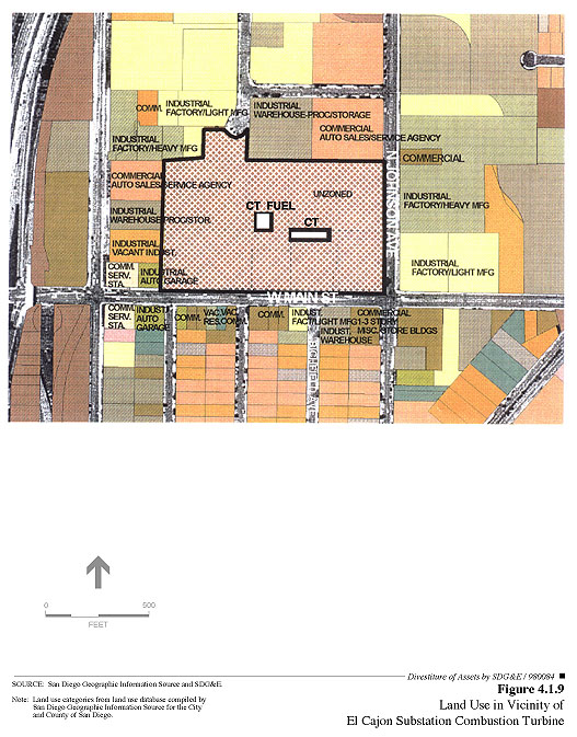
The El Cajon CT is east of Interstate 8 on the northwest corner of West Main Street and North Johnson Avenue, at SDG&E’s Eastern Construction and Operations Center. The Eastern Construction and Operations Center, which includes an electrical substation, is used for heavy commercial/light industrial uses associated with the construction and maintenance of the electric transmission facilities in eastern San Diego County. A parking lot is located to the north and east, the substation is located to the south, and a fuel storage facility is located to the west. The fuel storage facility is connected to the CT and is included in the proposed divestiture. Land uses to the north, south, and west of the center are commercial/industrial. Land to the east is zoned industrial and is currently used for a parking lot. The closest residential neighborhood is south of the commercial properties that line the south side of West Main Street. Interstate 8 provides east-west freeway access to the site and features an interchange approximately one block to the west.
North Island Naval Air Station CTs
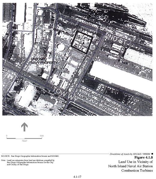
The North Island Naval Air Station CTs are located on Navy property near the intersection of Rogers Street and Quay Road. Surrounding land uses are military and industrial and include a natural gas terminal and a cogeneration facility. Other adjacent land uses are associated with the support of naval operations. Applied Energy, Incorporated (AEI) operates the cogeneration facility and has a long-term agreement to supply the Navy with steam and electricity. This contract provides that AEI may contract with SDG&E for the right to use the exhaust heat from the SDG&E CTs to supply the Navy with steam. In both of its agreements with SDG&E and AEI, the Navy has expressly reserved the right to limit or restrict access in any manner considered to be necessary for national security. SDG&E’s contract with the Navy for the use of the land on which these two CTs are located expired on September 28, 1998 and is currently being extended on a month-to-month basis. A residential area of the City of Coronado is located approximately 0.5 miles to the east of the CT site.
Miramar Yard CTs
The Miramar CTs are located at 6897 Consolidated Way within SDG&E’s Miramar Construction and Operations Center. A single 5621-barrel aboveground storage tank containing diesel fuel for the operation of the CTs is located to the west and is included in the proposed divestiture. Land uses to the north are commercial and to the east and west are industrial. Undeveloped areas of Marine Corps (formerly Naval) Air Station Miramar are located along the southern border. The site is within the Mira Mesa Community Planning area, on land designated for industrial use (City of San Diego, 1996). The site is also within Accident Potential Zone 1 on the Naval Air Station Miramar Comprehensive Land Use Plan (SANDAG, 1990). Conditionally compatible uses within this zone are offices, retail shops, wholesale stores, manufacturing, and outdoor uses; residential areas, schools, churches, and hospitals are incompatible in this zone. There are no residential land uses in the vicinity.
24th Street Terminal Refueling Facility
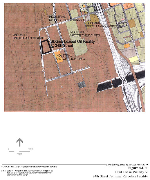
The 24th Street Terminal Refueling Facility is located 0.54 miles west of Interstate 5 in National City on lands owned and managed by the San Diego Unified Port District. This facility is being sold in conjunction with the South Bay Power Plant. The site is surrounded by Port District parking lots for new vehicles and storage yards for other goods that are being shipped through the National City Marine Terminal. Railroad tracks run along the western project boundary, while a lumber yard occupies the lands to the south and east. Vacant land is found to the north, beyond which is a large parking lot used for the storage and staging of new cars that have been shipped from Japan into the Port of San Diego’s Main Terminal at 24th Street and are awaiting distribution to local car dealers.
CHECKLIST ISSUES
a) General Plan Designations and Zoning
Encina Power Plant
Figure 4.1.1 shows the City of Carlsbad General Plan (1994) land use designations for the project site and surrounding lands. The land use designations for the project site are U (Public Utilities), covering the dry land, and OS (Open Space), covering the Agua Hedionda Lagoon. The Public Utilities designation allows such uses as "the generation of electrical energy, treatment of waste water, public agency maintenance, storage, and operating facilities, and other primary utility functions designed to serve all or a substantial portion of the community" (City of Carlsbad, 1994). The Open Space designation covering the Agua Hedionda Lagoon serves to preserve natural resources, aesthetics, and recreational resources. The project would not involve new construction, and any projected changes in operation (such as increased generation) would continue to be consistent with General Plan designations.
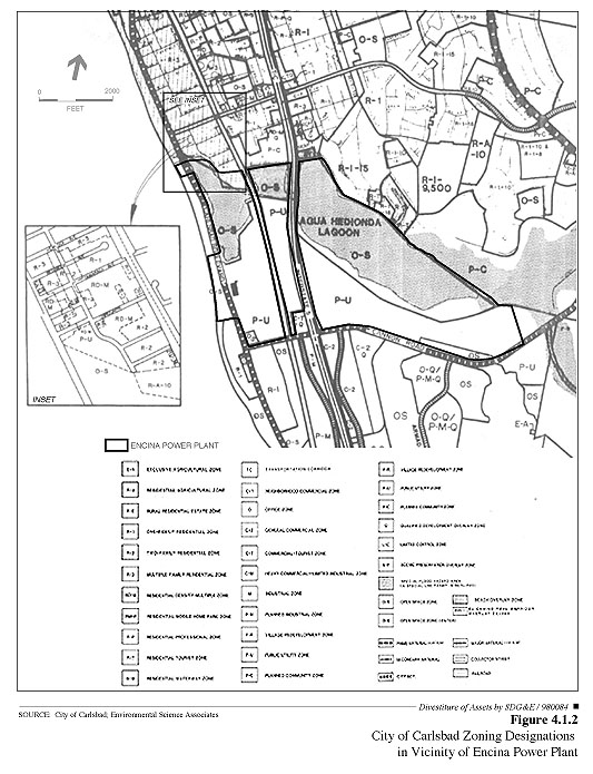
As shown in Figure 4.1.2, the City of Carlsbad zoning designations for the SDG&E property proposed to be divested are P-U (Public Utility), OS (Open Space Zone [Water]), and R-A-10 (Residential Agricultural) (City of Carlsbad, 1997). The Public Utility zone covers the majority of the dry land, the Open Space zone covers the waters of the Agua Hedionda Lagoon, and the Residential Agricultural zone covers a small portion of the dry land between the east and west lagoons. The generation and transmission of electrical energy is a permitted land use in the P-U zone; other permitted uses include energy transmission facilities; the processing, use, and storage of natural gas; and the use and storage of fuel oils. The facilities on site will continue to be used for electrical generation and transmission purposes. The Encina Power Plant is, and would continue to be under divestiture, consistent with City of Carlsbad zoning designations. Uses within the areas zoned OS would not be expected to change. The land zoned R-A-10 is currently leased to the Hubbs-Seaworld Research Institute. The existing lease would be transferred to the new owner, and future leases of the site would be subject to negotiation with the new owner. There is no reason to believe that a significant change of land use at this site would result from the project. The R-A-10 is a "Residential Agricultural" zone. It does not appear that the existing use conforms with this zoning designation. However, the sale would not increase or exacerbate that inconsistency.
The P-U zoning regulations also specify that "no building permit or other entitlement for use in the P-U zone shall be issued until a Precise Development Plan has been approved for the property." At present there is no approved Precise Development Plan for the SDG&E lands that are zoned P-U. SDG&E submitted a Precise Development Plan to the City of Carlsbad in 1993, but it has not been processed or approved. Although that it does not appear that the lack of an approved Precise Development Plan causes the SDG&E lands to be out of compliance with the City’s zoning requirements, the Carlsbad Zoning Ordinance (Section 21.48.100) further exempts non-conforming public utility facilities (including power-generating stations) from requirements to conform with other applicable provisions of the zoning ordinance.
Because no new construction is proposed and because no substantial changes to existing operations are anticipated, divestiture of the Encina plant would be consistent with existing local land use regulations. If a new owner were to propose new construction requiring a building permit on the P-U lands or were to seek any other entitlement for use on the P-U lands from the City of Carlsbad, such new owner would likely need to prepare and obtain approval of a Precise Development Plan.
SDG&E proposes to reparcelize the lands on which the Encina Power Plant is located in order to separate the power generation assets from the power transmission and distribution assets. This action would involve a modification of lot lines through a lot line adjustment process. The lot line adjustment process would relocate existing property lines, but would not create new lots (SDG&E, 1997). SDG&E has stated that the lot line adjustments would conform to all applicable jurisdictional zoning requirements, including development standards for street frontage, minimum lot area, and width (Dodson, 1998).
South Bay Power Plant
The South Bay Power Plant property proposed to be divested is designated Industrial by the Chula Vista General Plan (1989), as shown in Figure 4.1.3. The General Industrial land use category, which applies to most of the site, permits electrical generating plants and liquefied natural gas plants, as well as research and development, light manufacturing, warehousing, and accessory uses such as administrative offices, among other uses. Additional allowed uses include large-scale warehousing, transportation centers, and public utilities. The South Bay Power Plant is therefore consistent with the General Industrial land use designation. The project would not involve any substantial new construction, and any potential changes in operation (such as increased generation) would continue to be consistent with General Plan designations.
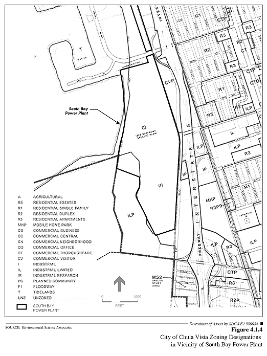
The South Bay Power Plant property proposed to be divested is zoned I (Industrial) (Figure 4.1.4). The Industrial zoning is intended by the City of Chula Vista to encourage sound industrial development by providing and protecting an environment exclusively for such development, subject to regulations necessary to ensure the purity of the airs and waters of Chula Vista and San Diego County, and the protection of nearby residential, commercial, and industrial uses of the land from hazards and noise or other disturbances. Specific permitted uses include electrical generating plants and liquefied natural gas plants. The South Bay Power Plant is consistent with current zoning, and any potential changes in operation (such as increased generation) resulting from the project would continue to be consistent with zoning designations.
Development in the area north of the South Bay plant and including part of the plant is guided by the Chula Vista Bayfront Land Use Plan, which is also the Phase II Chula Vista Bayfront Local Coastal Program (City of Chula Vista, 1983). The intent of the Bayfront Land Use Plan is to achieve a development plan consistent with the Chula Vista General Plan and the California Coastal Act. The portion of the South Bay Power Plant north of L Street is covered as Subarea 5 in the Bayfront Land Use Plan, and the entire project site is shown in the plan as Industrial. The plan, which indicates that the SDG&E generating plant is one of two major industrial facilities in the planning area, allows for the expansion of existing industrial facilities, although it does not allow additional non-coastal-dependent industrial use to occur beyond areas shown as industrial on the Land Use Plan. Lands adjacent to the South Bay Power Plant are designated for parklands, visitor-serving commercial, and research and limited manufacturing.
The South Bay Power Plant is currently in conformance with the Bayfront Land Use Plan and the Chula Vista General Plan. Because no substantial changes in operations are anticipated, and the only construction that may result from the divestiture would be minor (such as fences to separate transmission facilities from generation facilities), divestiture of the South Bay plant would be consistent with existing local land use regulations.
Kearny Construction and Operation Center CTs
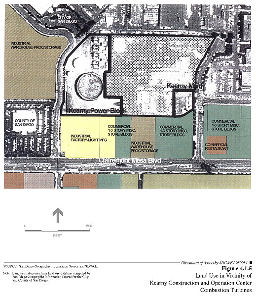
Land uses in the vicinity of the CTs at the Kearny site are illustrated in Figure 4.1.5. The Kearny CTs are located on land zoned for utility use and designated by the Kearny Mesa Community Plan for utility use. Because no substantial physical or operational changes to the CTs are projected to result from divestiture, operation of the CTs under the project would continue to be consistent with the Kearny Mesa Community Plan.
Naval Training Center, Division Substation, Naval Station, and North Island Naval Air Station CTs
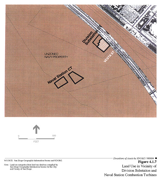
Land uses in the vicinity of the CTs at the Naval Training Center, Division Substation, Naval Station, and North Island Naval Air Station are shown in Figures 4.1.6, 4.1.7, and 4.1.8. Three of the CT sites are on military property and are not subject to local zoning or General Plan designations. Although the Division CT is on private property, it is surrounded by military property in an area designated as such in the local community plan. Because no substantial physical or operational changes are expected to result from divestiture, operation of the CTs under divestiture would not be inconsistent with General Plan regulations or zoning designations.
Leases for the placement and operation of the facilities on military lands are issued by the federal government for areas deemed appropriate. SDG&E’s access rights to the Navy property are provided through a service agreement between SDG&E and the Navy. Access rights held by SDG&E to the Navy properties would be transferred to the new owner.
El Cajon Substation CT
Land uses in the vicinity of the CT at the El Cajon site are illustrated in Figure 4.1.9. The El Cajon site is zoned Industrial and is designated Light Industrial by the City of El Cajon General Plan (1991). The El Cajon CT is in compliance with the local zoning and General Plan designation. Future use of the facility would be a continuation of the present use. Consequently, the project would be consistent with General Plan regulations and zoning designations.
Miramar Yard CTs
Land uses in the vicinity of the CTs at the Miramar Yard site are illustrated in Figure 4.1.10. The site is within the Mira Mesa Community Planning area, on land zoned for industrial use. The facilities proposed for divestiture are consistent with the Mira Mesa Community Plan and, as with the other CTs, would continue to be consistent with applicable General Plan designations under divestiture.
24th Street Terminal Refueling Facility
Land uses in the vicinity of the 24th Street Terminal Refueling Facility include oil handling and storage facilities and are illustrated in Figure 4.1.11. The 24th Street Terminal is within National City’s General Plan designation of Manufacturing Tideland-Coastal Zone-Unified Port District (Post, 1998), which permits public utility facilities that, because of technical requirements, must be located on or near the waterfront. Because these oil storage facilities are located on lands owned by the San Diego Unified Port District, the Port District has jurisdiction over land use at the site. The Port District’s Port Master Plan (1980) designates the 24th Terminal Refueling Facility site as "Marine-Related Industrial," and the Port District has issued Cargo Handling Permit No. 3574 to SDG&E for use of the terminal for fuel unloading and storage.
SDG&E’s lease with the Port District for the 24th Street site has expired and is being extended on a month-to-month basis (Morgan, 1998). If the 24th Street Terminal Refueling Facility is determined to be essential to the reliability and operation of the South Bay Power Plant, the Port District would be likely to enter into a new lease agreement with the purchaser. However, if the facility were found to be unnecessary, it is likely that the Port District would have the facility removed to provide space for the expansion of cargo handling and storage.
The 24th Street Terminal Refueling Facility is consistent with the Port Master Plan designation of the site for marine-related industrial use. Because no substantial changes are expected to result from the project, the facility would continue under divestiture to be consistent with applicable land use regulations.
Conclusion
The power generation facilities proposed for divestiture are in areas zoned and designated for uses that include power-generating facilities. SDG&E is not proposing any modifications to existing permits to be transferred or reissued to the new owners, nor are changes proposed to land use designations or zoning districts at any of the facilities.
Since no substantial land use, General Plan, or zoning conflicts would occur as a result of the project, the project would have a less-than-significant impact related to this checklist issue.
b) Applicable Environmental Plans
Encina Power Plant
The Encina Power Plant is located within the Coastal Zone and therefore is subject to provisions of the California Coastal Act. The plant is within the Aqua Hedionda Lagoon Local Coastal Planning Unit. Although the Aqua Hedionda Land Use Plan (City of Carlsbad, 1982) was adopted by the City of Carlsbad as the Carlsbad Local Coastal Program in 1982, it has not been certified by the California Coastal Commission, and the Commission retains permitting authority over development and related activities in the area. The Encina Power Plant site is consistent with the Aqua Hedionda Land Use Plan, which indicates that the site is a major energy generating facility.
See Sections 4.4, 4.5, 4.7, and 4.10 for discussions of applicable environmental plans pertaining to water, air quality, biological resources, and noise.
South Bay Power Plant
The South Bay Power Plant is located within the Coastal Zone and therefore is subject to provisions of the California Coastal Act. The plant is in an area designated as Industrial in the Chula Vista Bayfront Local Coastal Program Land Use Plan (Chula Vista, 1983), which has been certified by the California Coastal Commission (Anderson, 1998). Because no changes in land use are expected to result from the project, the continued use of the site as a power plant under divestiture would continue to be consistent with the Local Coastal Program Land Use Plan.
See Sections 4.4, 4.5, 4.7, and 4.10 for discussions of applicable environmental plans pertaining to water, air quality, biological resources, and noise.
Combustion Turbine Sites and 24th Street Terminal Refueling Facility
Except for the Kearny and El Cajon sites, the CT sites are located within the Coastal Zone and would therefore be subject to provisions of the California Coastal Act. Because federal property is exempt from state and local regulation, however, the three CT sites on Navy property and the Division site, which is surrounded by Navy property, are in areas exempt from Coastal Act provisions.
The Miramar Yard CTs are located in an area covered by the Mira Mesa Community Plan, which was certified as the Local Coastal Program Land Use Plan by the California Coastal Commission in 1993. The CTs are consistent with the site’s land use designation (Industrial) in the Mira Mesa Plan and therefore would also be consistent with the Local Coastal Program plan.
The 24th Street Terminal Refueling Facility is within the area covered by the Port Master Plan for the San Diego Unified Port District (Port District, 1980). The Port Master Plan was certified by the California Coastal Commission in 1981. The marine terminal is consistent with the Port District Master Plan, which designates the site as industrial and indicates that terminal uses include the receipt of petroleum and fuel oil products for SDG&E.
See Sections 4.4, 4.5, 4.7, and 4.10 for discussions of applicable environmental plans pertaining to water, air quality, biological resources, and noise.
Conclusion
The facilities proposed for divestiture are consistent with applicable environmental plans and policies, specifically the provisions of applicable Local Coastal Programs. The potential changes that could result from the project, such as minor construction activities and potential increases in generation levels, would not affect the consistency of the facilities with those plans and policies. Therefore, the impact of the project on applicable environmental plans and policies would be less than significant.
c) Existing Land Uses
Encina Power Plant
The land at the Encina Power Plant site, located in the City of Carlsbad, is currently being used—as it has been from more than 40 years—for the generation and distribution of electric power and associated supporting uses. Surrounding uses include residential uses to the north; residential, commercial, and industrial uses to the south; and open space to the east; the Pacific Ocean is to the west.
In addition to being the source of cooling water for the Encina Power Plant, the Agua Hedionda Lagoon is currently used for marine biological research, bird watching, aquaculture, a fish hatchery, fishing, boating, swimming, and other water sports. The beach on the Pacific Ocean is used for sunbathing, fishing, surfing, swimming, and other beach-related recreation.
The proposed sale of the Encina Power Plant would not have an impact on the existing uses of the Agua Hedionda Lagoon and beach areas on the Pacific Ocean, as SDG&E would transfer existing lease agreements for SDG&E lands included in the transaction to the purchaser.
Substantial development has occurred surrounding the Encina Power Plant since its construction over 40 years ago. Improvements made to the power plant over the years have been designed to minimize impacts to the surrounding community. These improvements include the construction of a very tall exhaust stack for maximum dispersal of pollutants and the shielding of noisy equipment with solid barriers. While the Encina Power Plant remains visible from many areas along the coast, SDG&E reports that few concerns are received from surrounding residents about plant operations (Waller, 1998). Operational characteristics of the plant are regulated, and no new construction is proposed as part of the project. A change in ownership would not result in a substantial change in the way the power plant would be operated; therefore, no significant impacts to adjacent or nearby land uses would occur from the sale of the Encina Power Plant.
South Bay Power Plant
The South Bay plant site, located in the City of Chula Vista, is currently used for the production and distribution of electricity and associated supporting uses. Surrounding land uses include industrial and recreational uses to the north; industrial uses to the south; and commercial and industrial uses to the east; San Diego Bay is to the west.
The South Bay Power Plant is consistent with the site’s designation (Industrial) in the existing Bayfront Land Use Plan, and development that has occurred to date along the bayfront near the power plant has proven to be compatible with the power-generating facility. As with the Encina Power Plant, there is no evidence that the South Bay Power Plant would be operated in a substantially different manner than is currently the case. Thus, there would not be a substantial change in land use impacts to adjacent properties.
Kearny Construction and Operation Center CTs
The Kearny Construction and Operation Center CTs are located in two separate portions of SDG&E’s Kearny Operations Center. The Kearny Operations Center, located in the City of San Diego, is devoted to the support of electricity generation and distribution. The CTs are in separate fenced areas that include control rooms, fuel storage tanks, pipelines, and wires. SDG&E would retain ownership of the land at this site and would provide the new owner of the CTs a right-of-access. The CTs would continue to be run on a periodic basis to meet peak demands for electricity and to provide a backup to the primary power plants. The land use at these facilities would remain unchanged.
The Kearny CTs are surrounded by commercial and industrial land uses compatible with the industrial nature of the SDG&E facility. The CTs are but a part of the larger SDG&E facility that would remain under the control of SDG&E after the divestiture. Existing fencing screens most views of the CTs from adjacent properties, while the exhaust noise and emissions are directed skyward to further minimize effects on surrounding properties. The sale and continued operation of the CTs would not be incompatible with adjacent land uses.
Naval Training Center CT
The Naval Training Center CT is located within a walled area that contains a cogeneration facility. This area, located in the City of San Diego, is exclusively used for the generation of electricity and steam and is not immediately adjacent to any other active land use. The new owner of the CT would be required to enter into a lease agreement with the federal government to continue to use the property. No change to the existing land use is anticipated at this location, as the CT is but a small part of the larger cogeneration facility and the military would continue to need a reliable source of energy in close proximity to its facilities.
The presence of endangered least terns within the fields to the east currently precludes development adjacent to the walled compound. This land is closed to human access and, as such, represents the only sensitive adjacent land use. As noted in Section 4.7 (Biological Resources), protection of this colony of least terns was addressed during the environmental review process for reuse of the training center. Continued operation of the CT should not preclude or be precluded by the use of the adjacent property by the endangered least tern.
Division Substation CT
The Division Substation CT is located adjacent to an electric substation, and the site is used exclusively for the generation and distribution of electricity. The site, located in San Diego near the northern border of National City, is surrounded by parking lots, roadways, and railroad tracks. The site is surrounded by military lands and provides the on-site capability for electricity generation. The sale and continued use of the SDG&E site for the generation and distribution of electricity would be compatible with the adjacent land uses, as the adjacent transportation corridors and use of the military lands for parking and supply distribution are not considered to be sensitive.
El Cajon Substation CT
The El Cajon Substation CT is located within SDG&E’s East County Construction and Operations Center in the City of El Cajon. The center is exclusively devoted to the support of SDG&E’s electric generation, transmission, and distribution facilities. Fuel storage tanks and pipelines that serve the CT are located a short distance to the west. SDG&E would retain ownership of the land at this site, and the new owner would be granted a right-of-entry (Russell, 1998). The project would not impact existing land uses at this facility, as the CT represents a small portion of the existing SDG&E operation and would continue to be operated on an as-needed basis to meet peak demands for electricity and to provide a backup to the primary power plants. The sale and continued operation of the CT, which is located well inside the SDG&E property line, would not be incompatible with commercial and residential areas to the south of West Main Street. All other adjacent land uses are commercial or industrial and are compatible with the existing uses of the SDG&E property.
North Island Naval Air Station CTs
The North Island Naval Air Station CTs, located in the City of Coronado, are adjacent to a cogeneration facility, a natural gas terminal, and naval operations support facilities. The CTs and the cogeneration facility are dedicated to the generation of electricity and steam and are surrounded by fuel storage and delivery facilities. The new owner of the CT would be required to enter into a lease agreement with the federal government to continue to use the property. No change to the existing land use is anticipated at this location, as the CTs are but a small part of the larger cogeneration facility and the military would continue to need a reliable source of energy in close proximity to their facilities.
All surrounding land use is military/industrial in nature and is compatible with the CTs. The sale and continued operation of the CTs would not be incompatible with existing adjacent land uses.
Miramar Yard CTs
The Miramar Yard CTs are located within SDG&E’s Miramar Construction and Operations Center in the City of San Diego, just north of the Marine Corps Air Station Miramar. The CTs are within a compound dedicated to the construction, operation, and maintenance of SDG&E’s electric generation, transmission, and distribution facilities. A large warehouse used by SDG&E primarily for records storage and gas meter calibration is located to the north.
The CTs represent a small part of the existing land use and provide the on-site capability for electricity generation. Undeveloped land surrounding the runways at Marine Corps Air Station Miramar is south of the CTs. Industrial, warehouse, and light manufacturing land uses are found to the east and west, while commercial uses are found to the north, north of Consolidated Way and Miramar Road. The divestiture and continued operation of the CTs would be compatible with these existing land uses, and no significant impacts would result.
Naval Station CT
The Naval Station CT, located in the City of San Diego, is surrounded by a cogeneration facility. The combined unit is used exclusively for the generation of electricity and steam and is surrounded by fuel storage and delivery facilities. The new owner of this CT would be required to enter into a lease agreement with the Navy for the continued use of this site.
Surrounding military land uses are industrial in nature and are compatible with the continued operation of the Naval Station. No significant impacts to existing land uses would result from the proposed divestiture.
24th Street Terminal Refueling Facility
The 24th Street Terminal, located in National City, is used for the off-loading of petroleum that is used as an emergency fuel source for the South Bay Power Plant. The site contains three storage tanks as well as associated pumps and pipelines and is used exclusively to receive, store, and transport fuel oil for use at the power plant. This facility received its last shipment of fuel oil in 1993. Fuel oil is used very infrequently at the South Bay Power Plant as the primary fuel; natural gas is cleaner and more cost effective.
The continued use of the 24th Street Terminal for fuel off-loading, storage, and transport to the South Bay Power Plant is not assured, but would be compatible with the adjacent port-related land uses. As stated previously, the 24th Street Terminal Refueling Facility would be sold in conjunction with the South Bay Power Plant. The San Diego Unified Port District has indicated that it would continue to lease the site to the new owner(s) of the South Bay Power Plant if the 24th Street Terminal is necessary for plant operations (Morgan, 1998). If the tanks and pipelines are determined to be no longer necessary for plant operations or reliability, they would be removed and the site would be used for other port-related uses similar to the surrounding land uses. The continued use of the site for the storage of fuel oil or for other port-related land uses, such as the storage of lumber, vehicles, or other import/export goods, would not be considered significant. The divestiture would be consistent with existing and surrounding land uses.
Conclusion
The existing power generation facilities have been operating in their current locations for over 25 years. No changes in operational or land use conditions have been proposed at any of the facilities or on surrounding lands. The 24th Street Terminal is the only site where a potential for a change in land use has been identified, and that potential change would not be significant. Any possible future changes in land uses of the sites and facilities proposed for sale are not reasonably foreseeable at this time and would be subject to future environmental review and discretionary action. The proposed project, therefore, would not have a significant impact on existing land uses.
d) Agricultural Resources
Encina Power Plant
The lands proposed for divestiture are not used for agriculture and contain oil storage tanks, parking lots, and other development features associated with the generation of electricity. None of the land to be divested is considered suitable for agriculture due to the lack of tillable lands and proximity to the power plant and related facilities.
SDG&E lands to the east of Interstate 5 are currently used for agriculture. The proposed divestiture, however, does not involve these lands. None of the lands at the Encina Power Plant are used for agriculture or have been used for agriculture since the site was purchased by SDG&E in the late 1940s.
South Bay Power Plant
The South Bay Power Plant contains the largest areas of unpaved and undeveloped lands of the SDG&E lands to be divested. These undeveloped areas, however, are crossed by railroad tracks, oil pipelines, and electric transmission and distribution lines and are within the fenced South Bay Power Plant property. Restricted access to the site, surrounding industrial land uses, and the presence of numerous power poles, pipelines, roads, and railroad tracks make the site unsuitable for agriculture.
None of the lands at the South Bay Power Plant have been used for agriculture since development of the site for the power plant began in 1957. There would not be an impact to agricultural resources.
Combustion Turbines and 24th Street Terminal Refueling Facility
The CTs and the 24th Street Terminal are all located on developed land within industrial settings that have either been paved or graded. No agricultural resources are present at these facilities
Conclusion
The two fossil-fueled power plants, 17 CTs, and the 24th Street Terminal are all located on developed properties within urban environments. The sites are all paved or graded and covered with gravel. Their lack of tillable soil, small size, and proximity to other industrial uses make them unsuitable for agriculture.
SDG&E would retain ownership of the land at the non-military CT sites, while the military would retain ownership of its property and the San Diego Unified Port District will retain ownership of the 24th Street Terminal property. None of the lands proposed for divestiture are currently used for agriculture; thus, there would not be any impact to agricultural resources.
e) Physical Arrangements of Communities
Encina Power Plant
The Encina Power Plant is located in an established community and has been a local feature along on the coast since 1954. The Agua Hedionda Lagoon creates a natural barrier between the residential neighborhoods to the north and the residential neighborhood to the south. The sale of the Encina Power Plant would not affect the existing physical arrangement of the City of Carlsbad.
South Bay Power Plant
The South Bay Power Plant is located on the bayfront, west of Interstate 5, and is surrounded by light industrial, commercial, and park uses. Interstate 5 separates the bayfront areas and the associated industrial land uses from the residential neighborhoods and the central business district that are all located east of the freeway. The South Bay Power Plant has been a local site on the bayfront since 1960, and its sale and continued operation would not affect the physical arrangement of the City of Chula Vista.
Combustion Turbines and 24th Street Terminal Refueling Facility
The CTs and the 24th Street Terminal are located in industrial settings on military property, San Diego Unified Port District property, or on property owned by SDG&E. There would not be a change in ownership of the land associated with the divestiture of these electrical generation assets. There also would not be a change in land use, as the CTs would remain in place and would continue to be used to meet peak power demands and to provide backup power supplies in case of an emergency.
Conclusion
The proposed divestiture would not have any impact on the physical arrangement of the communities in which the Encina plant, South Bay plant, the CTs, or the 24th Street Terminal are located. Any physical changes at the SDG&E facilities would be minor and would be limited to new fencing or access roads within already restricted areas. The divestiture would not result in the disruption or division of the physical arrangement of an established community.
REFERENCES — Land Use and Planning
Anderson, Debra, Chula Vista Planning Department, telephone communication, October 1, 1998.
City of Carlsbad, The Magic of Carlsbad, http://www.Carlsbadca.org, May 18, 1998a.
City of Carlsbad, Carlsbad General Plan Land Use Map, updated January 1998.
City of Carlsbad, Carlsbad Zoning Ordinance, as amended through February 1998.
City of Carlsbad, Carlsbad Zoning Map, updated October 1997.
City of Carlsbad, Carlsbad General Plan, September 6, 1994.
City of Carlsbad, Aqua Hedionda Land Use Plan: City of Carlsbad Local Coastal Program, May 1982.
City of Chula Vista, Chula Vista General Plan , July 11, 1989, reprinted with revisions September 1995.
City of Chula Vista, Chula Vista Bayfront Land Use Plan, Phase II Chula Vista Bayfront Local Coastal Program, September 1983.
City of Coronado, Coronado–1990: The General Plan, undated.
City of Coronado, Zoning Ordinance, undated.
City of El Cajon, El Cajon General Plan 2000, January 8, 1991, as amended February 10, 1998.
City of San Diego, Mira Mesa Community Plan, October 6, 1992, as amended December 3, 1996.
City of San Diego, Barrio Logan/Harbor 101 Community Plan, 1978, as amended 1993.
City of San Diego, Redevelopment Plan for the Barrio Logan Redevelopment Project, May 20, 1991.
City of San Diego, Kearny Mesa Community Plan, October 6, 1992.
City of San Diego, Midway/Pacific Highway Corridor Community Plan and Local Coastal Program Land Use Plan, May 28 1991, certified by the California Coastal Commission, September 11, 1991.
City of San Diego, Peninsula Community Plan and Local Coastal Program Land Use Plan, July 14, 1987.
Dodson, James R., Attorney, San Diego Gas and Electric Company, meeting at Encina Power Plant, April 22, 1998.
Morgan, L. Thomas, Senior Director, Real Estate Operations, San Diego Unified Port District, meeting at San Diego Unified Port District Offices June 10, 1998.
P&D Technologies, San Diego Gas & Electric Encina Power Plant Precise Development Plan, Draft, prepared for SDG&E Land Services, February 1993.
Post, Roger, National City Planning Director, meeting at National City Planning Department, May 13, 1998.
Russell, Charlie, San Diego Gas & Electric, site visit to CTs, April 23, 1998.
San Diego Association of Governments (SANDAG),Comprehensive Land Use Plan, Lindberg Field, San Diego, 1992, as amended April 1994.
San Diego Association of Governments (SANDAG),Comprehensive Land Use Plan, Naval Air Station Miramar, October 1990, as amended September 1992.
SDG&E, Proponent’s Environmental Assessment: San Diego Gas & Electric Company’s Proposed Sale of It’s Electrical Generation Facilities and Power Contracts, December 19, 1997.
San Diego Unified Port District, Port Master Plan, January 1980, revised September 1990.
U.S. Navy North Island Naval Air Station, Welcome Aboard Naval Air Station North Island, http://www.nasni.navy.mil, April 24, 1998.
Waller, Don, Environmental Manager, San Diego Gas & Electric, meeting at Encina Power Plant, April 22, 1998.
| TOP | Forward to Next Section (Population and Housing) |
Back to Previous Section (Approach to Environmental Analysis) |
Back to Initial Study Table of Contents | SDG&E Main Page | CPUC Home Page |